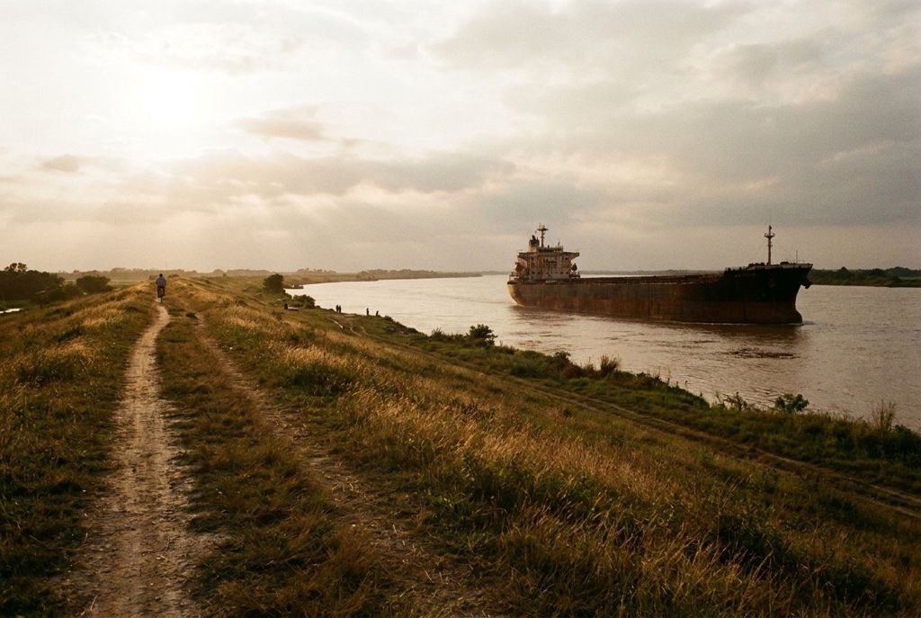
The Lower Ninth has water on two sides: the Mississippi to the south, with its ships and skyline, and the open wetland of Bayou Bienvenue to the north, where a cypress swamp once grew.
- Ride
- About 3 miles between the two
- Surface
- Levee grass, path, city streets
- Best months
- October to April, early mornings
- Getting there
- Caffin Avenue links the river and bayou
- Bring
- Water, insect repellent, binoculars, a light layer
Heads up: Mosquitoes rise at dusk near the bayou, and the levee top has no shade at all. Bring repellent for sunset and plan the levee for the cooler hours.
Most of the Lower Ninth Ward is houses and streets, but its two edges are water. To the south runs the Mississippi River, held back by a long grassy levee. To the north, past Florida Avenue and the floodwall, lies Bayou Bienvenue, a broad sheet of open water and marsh. Riding from one to the other is one of the simplest and most rewarding rides in the ward, and it tells you a great deal about how this land was made and how it has changed.
Up on the river levee
In Holy Cross the streets run straight down to the foot of the levee. Walk your bike up the slope and the city changes in a moment. From the top you look out over the Mississippi at one of its great bends, with the downtown skyline upriver and ships moving in both directions: tankers, cargo vessels, tugboats pushing long strings of barges.
The levee top is open ground, with grass on the slopes and a path along the crown in places. Riding conditions on the top vary; some stretches are easy, others rough or fenced. Treat it as somewhere to stop, sit and watch rather than a fast route, and check what is open before relying on it.
A few things worth knowing:
- There is no shade. Midday in summer is punishing up here.
- The river is wide, deep and fast. Stay off the batture, the land between the levee and the water, where footing is poor and currents are dangerous.
- The levee is flood protection, not a park. Do not damage the grass or ride down steep slopes.
Late afternoon is a fine time for the river view, as the light warms over the water and the skyline. Morning is cooler and quieter.
Look upriver along the Holy Cross shore and you can make out where the Industrial Canal meets the Mississippi through a lock. Ships and barges sometimes wait nearby for their turn to pass, and watching one edge in or out is a slow, absorbing show. The canal is the same water that runs past the western edge of the ward, and the same channel that the low St. Claude Avenue bridge opens for.
From river to bayou
The two edges of the ward are a short ride apart. Caffin Avenue is a good line between them: it runs from Holy Cross, across St. Claude and North Claiborne, past Florida Avenue to the edge of the wetland. Along the way you pass from the older houses near the river into the open, grassy blocks farther north, where the 2005 flood was deepest.
Take your time on this stretch. It is a residential street the whole way, and the change in the landscape is part of what you came to see. The story on the years since 2005 explains what happened here.
Pairs well with: Fats Domino and the music of the Ninth Ward
The platform over Bayou Bienvenue
At the northern edge of the ward, near the end of Caffin Avenue, a wooden viewing platform reaches out over the water. It was built after the flood so that residents and visitors could see and learn about the wetland behind their neighbourhood. From it you look across a wide, open triangle of water and marsh grass, with the city's eastern skyline on the horizon.
What you see is not what was here a few generations ago. Bayou Bienvenue was once a cypress swamp, dense with trees. In the mid-twentieth century, navigation channels were dug through the wetlands to the east, and salt water from the Gulf made its way into the swamp. The cypress trees could not survive it. Many died standing, and their grey stumps still break the surface in places.
The loss mattered for more than its beauty. Healthy swamps and marshes slow storm surge before it reaches a city, and people in the ward know well how exposed the neighbourhood became. Work to restore parts of the wetland has gone on for years, and the platform is a good place to think about what a stretch of open water means to a low-lying neighbourhood.
Sunset and mosquitoes
Evening is the platform's best hour. The sun goes down to the west, the water takes on the colour of the sky, and birds move across the marsh: herons, egrets and others, depending on the season. Binoculars help.
Evening is also when the mosquitoes come out, and near the wetland they come out in numbers. Wear repellent, cover your arms and legs if you can, and do not linger too long after dark. The ride back south passes through quiet streets with patchy lighting, so carry front and rear lights and use them.
Putting the two together
A pleasant way to do this is to start at the river in the morning or late afternoon, ride north on Caffin, spend time at the platform, then come back by a different street, perhaps passing the Steamboat Houses on the way to the levee once more. The full loop is short, and on flat ground it takes little effort. In the hot months, though, the open levee and the bare blocks to the north leave you exposed, so carry water and watch the sky. The notes on heat and afternoon storms are worth reading before a summer ride.